In these divisive times, there’s one thing everyone agrees on: Traffic here is terrible. With road improvement projects going on all the time—especially now, in construction season—why does it seem our roads aren’t keeping up with traffic?
Because, in fact, they aren’t. Charles Proctor, planning manager for Virginia Department of Transportation-Culpeper District (which includes Charlottesville, Albemarle County, and eight other counties) has worked on traffic planning in this area for more than 20 years. His assessment: “Lots of our projects now are more reactive than proactive.”
Plenty of factors are at play, including local growth.
From 2020 to 2025, while the population of the city stayed essentially level, Albemarle County grew by 6.3 percent; for comparison, in that same five-year period, the University of Virginia student body grew 4 percent while UVA employment grew by 22.5 percent. Factor in that Charlottesville and Albemarle are competing for state funding with every other county and locality in the Commonwealth, under an evaluation system that favors addressing current problems over forecasted ones. Then, add in that the Commonwealth allocates its transportation funding on a six-year timeframe, and you can see why road improvements are always playing catch-up.
It’s not that people and jurisdictions aren’t trying, but the process is enormously complex. When C-VILLE contacted Kevin McDermott, deputy director of planning for Albemarle County, his
response when asked about the traffic-planning process was, “Are you writing a book?”
How are problems identified?
To define the problem, VDOT uses video collection at intersections and tube counters (rubber hoses that are stretched across lanes and triggered by tires driving over them) on roadways to monitor traffic flow. Accident data from police departments is also factored in, as is information from UVA’s Weldon Cooper Center for Public Service, which tracks a wealth of local statistics for local jurisdictions and for the state. Then there are VDOT’s monthly meetings with its localities—and yes, complaints from residents. Albemarle County concerns can be submitted on its website; in Charlottesville, traffic issues can be reported through the MyCville app or by emailing traffic@charlottesville.gov. Ben Chambers, the city’s transportation planning manager, says, “A lot of what we are doing is in response to what residents are saying.”
According to Chambers, “We don’t have space to do much with the roads—and we have a road system from the 1700s. Our strategy has to be, provide other options [beyond cars].” Charlottesville requires development projects to submit a traffic demand management plan as part of the approval process, but increasingly, the goal is to foster other modes of getting around. “The city is three miles across—that’s a 20-minute bike ride,” says Chambers, but he notes “there are costs even for sidewalks and bike lanes.”
One big factor in Charlottesville’s traffic flow: UVA, the city’s largest landowner and its biggest employer. “The UVA campus and UVA employment are big destinations,” says Chambers, and meeting that need for transportation (while controlling the numbers of cars on the roads) has to include public transit, bike lanes and parking stations, and the ubiquitous VEO scooters.
Who owns the roads?
Let’s say a problem site has been identified—for congestion, safety, or a high rate of serious accidents. Who’s responsible for addressing it?
Albemarle County’s roads are owned by the state. Funding for basic repair and maintenance is available through VDOT’s Charlottesville Residency (its local office near Pantops), but any substantial needs must be met through state approval and funding.
The City of Charlottesville, as an independent city, owns its own roads, and its capital budget has allocations for the Department of Public Works (signals, signage, roadway maintenance and sidewalk repair) and the Neighborhood Transportation Improvements Program (small-scale projects). For larger project funding, the city has to go to City Council or to the state through the Commonwealth Transportation Board.
Clearly, though, city and county roads and traffic are closely interrelated. The two jurisdictions are members of the Thomas Jefferson Planning District Commission, through which in 1982 they established the Charlottesville-Albemarle Metropolitan Planning Organization. VDOT-Culpeper is on both the CA-MPO Policy Board and its Technical Committee, and collaborates with the county and city as well as with UVA and the regional transit and Federal transportation agencies.
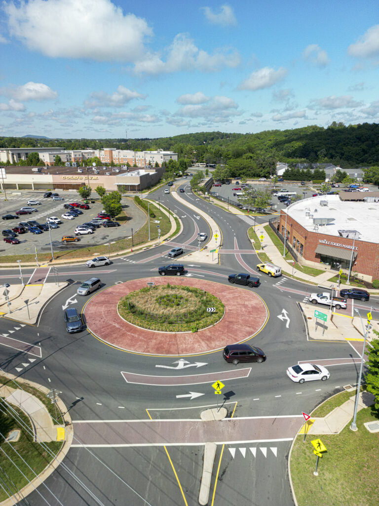
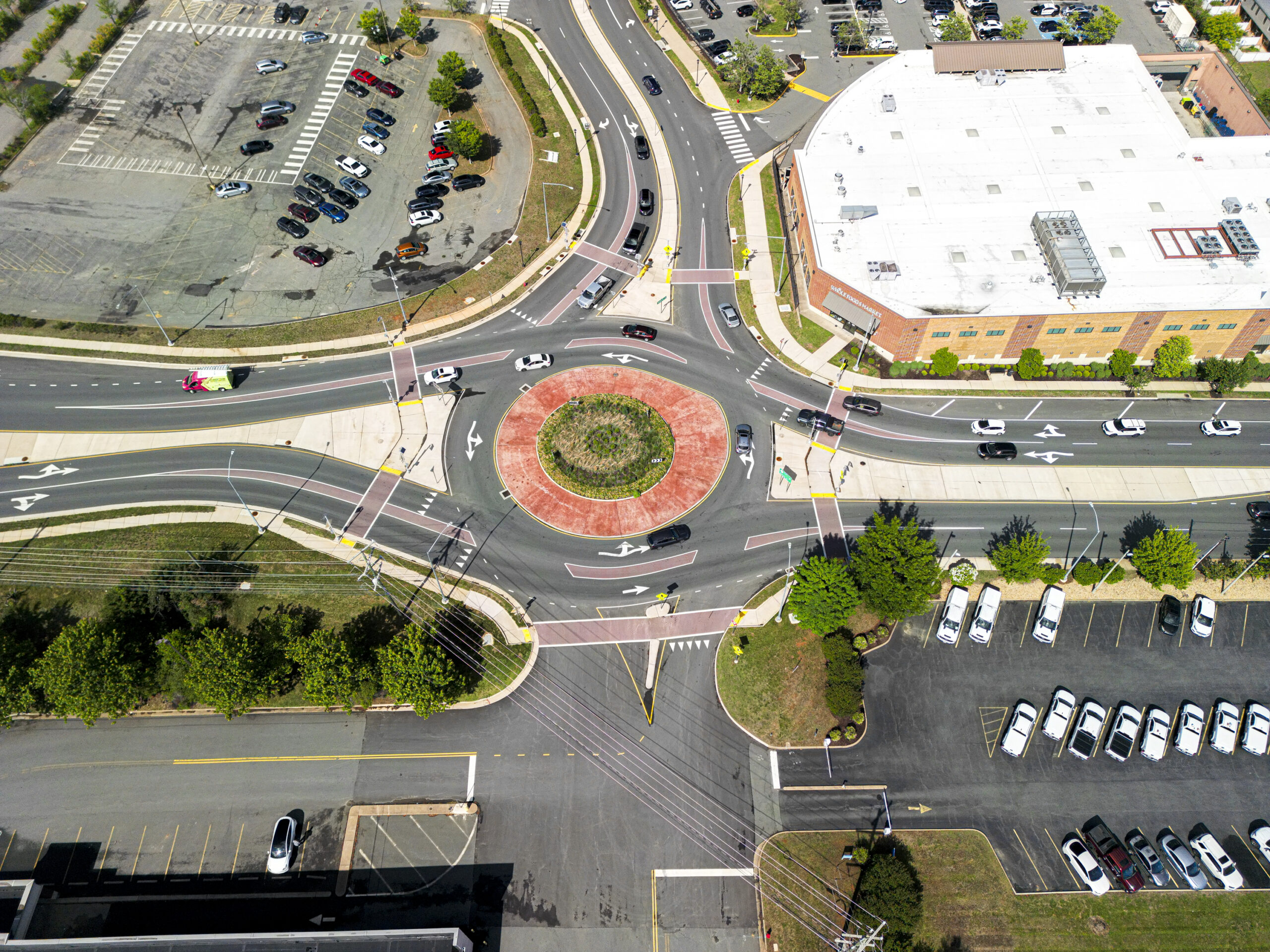
The two-lane hybrid roundabout near Whole Foods on Hydraulic Road at Hillside Drive, which opened in August 2024, had been the site of several crashes thanks to congestion and confused drivers.
Where does the money come from?
Funding for major projects, however, doesn’t get allocated by our local VDOT district. All major road construction and improvement proposals have to go through the Commonwealth’s funding process, competing against other projects statewide for a slice of the limited pie—$58.4 billion for FY 2026-2031.
Major projects are fed through SMART SCALE, a process that evaluates projects based on factors such as safety improvement, congestion reduction, increased accessibility, contribution to economic development, efficient land use, and environmental impact. SMART SCALE scores and ranks proposals, and, after a public review and comment period, the Commonwealth Transportation Board selects projects to be approved and funded.
This process is why road improvement projects take so long. A proposal can take one to two years to be developed and submitted to SMART SCALE, which operates on a two-year cycle from application to selection. If the proposal gets selected, it’s funded under the state’s Six-Year Improvement Program, so the funding may not come through for four to six years. Once funded, the project goes out to bid on engineering and design (one to two years), after which construction usually takes one to two years. And that’s if the proposal is accepted the first time around; if, as often happens, it has to be revised and re-submitted, the whole process starts again.
As an example, the intersection of Route 240 (Three Notched Road), U.S. 250 (Rockfish Gap Turnpike), and Route 680 (Browns Gap Turnpike) east of Crozet had been flagged as a congestion and safety problem for years. A proposal for a roundabout was submitted to SMART SCALE in 2016, but not funded; a subsequent effort to get federal funding was approved, but shelved when construction costs soared during COVID. In early 2023, VDOT decided to resubmit that proposal as part of a bundle of Albemarle County projects, to help reduce costs. Construction began in May 2025 and was completed in March this year.
About those roundabouts …
Mention roundabouts, and you’ll probably get an earful. Love ‘em or hate ‘em, why are so many roundabouts springing up in this area?
To traffic planners, roundabouts (or traffic circles, the larger versions that may have stop signs or traffic signals in them) are often the way to go; McDermott declares, “I’m in the camp of loving them.” According to the Federal Highway Administration, roundabouts are safer due to their reduced conflict points (eliminating left turns against oncoming traffic, one of the most dangerous aspects of a regular intersection) and slower speeds (15-25mph on average). FHA figures show roundabouts reduce intersection crashes that result in death or injury by 82 percent on average.
The safety factor is all in the design. Road engineers lay out the approaches to roundabouts to slow entering traffic (as opposed to signal lights, which McDermott says “make people speed up—they’re trying to beat the light”). At a slower speed, if an accident occurs it’s likely to be less severe for both people and vehicles. And those accident figures—and costs—are data points that go into setting insurance rates in Virginia.
Roundabouts are also designed to keep traffic moving. The FHA says roundabouts can reduce traffic delays by 62-74 percent; “a roundabout can process more cars in an hour than a signal,” says McDermott. The result: less emissions from idling vehicles, and less frustration from waiting through several signal changes at times of heavy traffic flow. In addition, drivers entering a roundabout only have to look one way (to the left) rather than both ways to detect approaching traffic.
An important factor: SMART SCALE uses a cost/benefit approach that favors innovative solutions that provide greater benefits at lower cost. In addition to roundabouts, this includes diverging diamonds (Route 250 and I-64 at Pantops); continuous green-T intersections (protected left turn, soon to be constructed at Rio Road East and Belvedere Boulevard); and restricted crossing U-turns, or R-cuts (the North Pointe entry on 29 North).
Of course, a roundabout isn’t always the best or even a possible solution. The layout requires a certain amount of space, especially if the traffic passing through includes a high percentage of big trucks and industrial vehicles with a larger turning radius. Roundabouts don’t work well on slopes, which is one reason hilly Charlottesville doesn’t have many of them.
Critics say that roundabouts take up land and create more impermeable surfaces. McDermott points out that increasing signaling complexity (adding turn lanes, for example) also requires more space, and roundabouts are increasingly being designed with non-paved centers to allow for rain absorption.
But the basic reason that people object to roundabouts is that most American drivers haven’t learned to navigate them. As roundabouts become more common, drivers will have to get with the program. Chambers notes that “virtually every corridor into the city has a roundabout”—installed or planned. Recognizing that, driver’s education classes in Albemarle County schools now teach students how to handle a roundabout. Just like learning to ride a bike, it takes practice.
According to Kevin McDermott, deputy director of planning for Albemarle County, “a roundabout can process more cars in an hour than a signal.” The result: less emissions from idling vehicles, and less frustration while waiting through several signal changes when traffic is heavy.
What’s next?
The good news is, a solution for the traffic problem you’re venting about today may already be in the pipeline. A visit to the Culpeper District projects page on the VDOT website shows proposals for a roundabout on Hydraulic Road at District Avenue (to mitigate the impact of eliminating the left turn from Hydraulic onto southbound 29/Emmet Street); an extension of Berkmar Drive as far as Airport Road; and reconfiguration of the 250 Bypass/Fontaine Avenue intersection to manage congestion from UVA Health South’s expansion and replace the left turn across northbound 29/250 Bypass to reach I-64 West.
Then there are the projects already set for construction, including: a park-and-ride lot near I-64 Exit 107 in Crozet, a multi-lane roundabout at Rio Road East and John Warner Parkway, a roundabout at Routes 20 and 53 (at the turnoff for Monticello), and a redesign of the Route 20/250 intersection at Pantops
Clearly, we’re in for a lot of road construction. And these are just the projects that directly affect Charlottesville; there are also studies and proposals to address issues for Fluvanna and Orange counties, Zion Crossroads, and the entire Route 29 corridor. But one thing is for sure: By the time these projects are proposed, approved, designed, and constructed, there will be new congestion points and overloaded roadways.
The underlying question is, how will our area manage the growth that we keep inviting? As VDOT’s Proctor points out, “Land use is controlled by the localities.” That means the traffic planners can review comprehensive plans, require traffic impact studies, and forecast traffic needs—but in the end, it’s our elected officials who decide when, where, and how much development will happen. And they work for us.
Roundabout: 101
Need help understanding how roundabouts work? Here’s how to do it.
Slow down before you enter: The objective is to enter the roundabout at the speed of traffic in it. If it’s a multi-lane roundabout (like the one at Hillside and Hydraulic roads near Whole Foods), look for signs that tell you which lane to use whether you intend to turn right, go straight through, or turn left.
Yield to traffic coming from the left: Traffic only goes one way in a roundabout. If someone’s coming around, let them pass before you enter. It’s like merging—you’re joining moving traffic.
Enter when it’s clear: Once there’s a safe gap, glide in smoothly. Don’t stop abruptly or gun it.
Stay in your lane: Don’t change lanes unless signs or markings specifically say so.
Signal your exit: Use your signal so other drivers know what you’re doing.
Or, just memorize the FHA’s simple mantra: “Slow down, look around, be ready to yield.”
Continuous flow
| City of Charlottesville West Main and Ridge streets | Albemarle County Fifth St. Extended and Old Lynchburg Road |
| 2015-2016: Funds awarded as part of the West Main Streetscape project. | 2017: Intersection flagged as an issue. |
| 2021: Inflation and competing needs led city to withdraw matching funds, canceling this part of the project. | 2018-2019: Planning efforts start, different proposals evaluated. |
| 2024: VDOT offers city planning support through the VDOT STARS program. | Summer 2020: Final planning study completed; SMART SCALE application approved by County and CA-MPO. |
| April 2026: City submits a SMART SCALE pre-application to VDOT. | Late 2020: VDOT accepted SMART SCALE application. |
| July 2026: City Council is anticipated to endorse full SMART SCALE application. | May 2021: Proposal approved through SMART SCALE evaluation process. |
| August 2026 – January 2027: SMART SCALE applications will be scored and evaluated. | July 2021: State funding made available. |
| Spring 2027: SMART SCALE applications will be selected for inclusion in the Six-Year Improvement Program. | Summer 2022: VDOT began preliminary engineering. |
| 2029/2030: If project is approved, engineering and design work will begin. | Spring 2024: Engineering firm hired. |
| 2033/2034: Funding becomes available and construction begins. | Spring 2026: Construction begins. |
| 2035: Project forecasted to be completed. | November 2027: Project scheduled to be completed. |