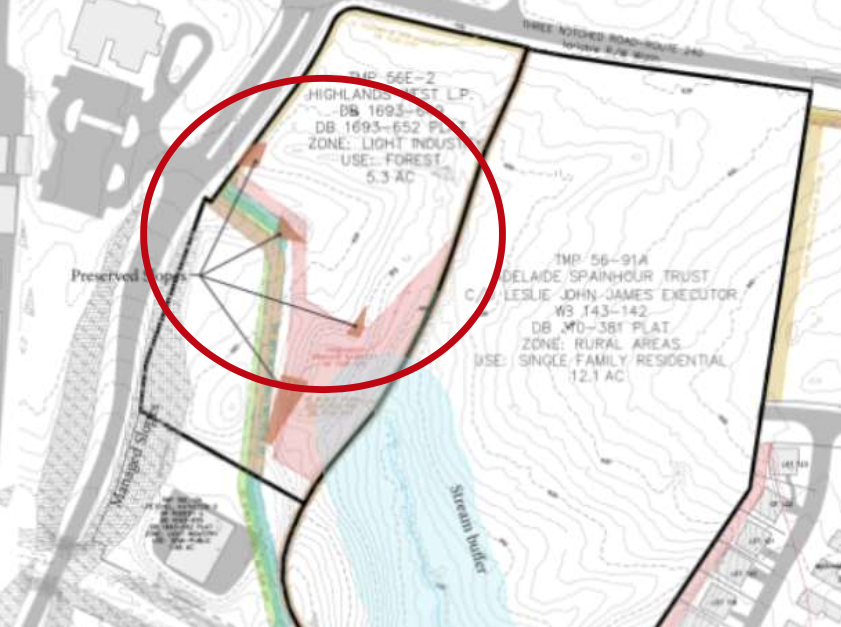
Eric Schmitz came back from the holidays last December and found a letter about plans to develop 17.5 acres on two parcels in front of Western Ridge in Crozet. “I know it well,” he says. “The future development was on top of a stream.” But on the Albemarle County map, the stream was no longer there.
He attended a Crozet Community Advisory Committee meeting about Montclair, the proposed 157-unit development off Route 240, where he was told that when county officials went out there, there was no stream, says Schmitz. “My eyes weren’t lying.”
Why a county stream, which has been on maps for 170 years and is presumably protected by Albemarle’s Water Protection Ordinance, was removed—along with its 100-foot buffers on each side—from county GIS maps shortly before the Board of Supervisors approved the Crozet Master Plan in October 2021, and before a developer asked for a rezoning to build on the stream site, is not crystal clear.
“We don’t have a good sense of why that happened,” says Joe Fore, chair of the Crozet Community Advisory Committee, which had been reviewing the master plan. “The first thing that seemed strange was that it was very late in the process. People felt blindsided. There was no chance to review.”
The plans to rezone the site sans stream, originally reported by Crozet Gazette, drew widespread opposition among Crozetians, who formed Crozet United and filed a citizen suit under the Clean Water Act against the U.S. Army Corps of Engineers. The basis of the complaint, says Schmitz, is that the developer piped a stream under an invalid permit.
On March 20, 2021, county engineer Frank Pohl and the Army Corps’ Vinny Pero found a stream on the property, according to an email from Pohl obtained under the Freedom of Information Act. By August 31, 2021, Pohl says the map will change because the owner of the parcel—Highlands West LP—had piped a section of the stream.
During summer 2021, Montclair’s engineer, Justin Shimp, buried a 203-foot portion of the stream, says an email from Shimp Engineering. The county did not require a permit because Shimp said he was moving under 10,000 square feet of earth, explains Pohl in a January 21, 2022, email to Schmitz and Albemarle County Supervisor Ann Mallek.
Shimp received a verbal okay from the U.S. Army Corps of Engineers under its Non-Reporting Nationwide 18 permit, says the email. Once the stream was underground, the segment no longer required a 100-foot buffer.
Shimp, who has been stalled on other projects involving water, most recently the 0 East High Street 245 apartments in the Rivanna River floodplain, did not return multiple phone calls from C-VILLE.
Through the course of 168 pages of FOIAed emails, county officials began to say the Army Corps had designated the remaining segments of the stream “ephemeral,” making them eligible to be removed from the map as well.
Not true, say three Corps officials, who denied ever reclassifying the stream as ephemeral in a July 22 email. Nor does the group determine whether to remove a stream from the map, says the Corps’ Pero. “We just determine whether it’s a ‘water of the United States.’” And he confirmed that the Montclair stream was, indeed, a “water of the U.S.”
Schmitz calls the ability to pipe streams without county oversight a huge loophole, and he believes a developer could bury an entire stream by doing it in segments. He worries that the same dodging of the Water Protection Ordinance could happen again. “Everyone understands it’s broken,” he says.
Even Mallek, whose White Hall District includes Crozet, had a hard time getting a straight answer about the “stream erasure.” In a September 5 memo to her fellow supes, she writes, “Despite repeated requests from me since January and again March 2022, and from residents at CCAC and to County staff by community members, the only documentation presented for erasure of the stream in the last days of adoption of the Crozet Master Plan is a reported word of mouth declaration by the [Corps] of non-stream status. Now we learn that report is not accurate.”
Despite the Corps’ assurance that the stream existed, Community Development Director Jodie Filardo announced at the September 6 supervisors meeting the hiring of an outside consultant to determine whether the two unpiped segments of the stream were, in fact, intermittent streams that required 100-foot stream buffers under the county’s Water Protection Ordinance.
Filardo noted a “conflict of interest” with county engineer Pohl, who used to work for developer Vito Cetta. County spokesperson Emily Kilroy clarifies that Filardo used “conflict of interest“ in a “colloquial sense,” not a legal one implying financial interest. “There was a concern there may be the perception of a conflict because over a decade ago he worked for the applicant.”
On October 13, Ecosystem Services determined both stream segments were intermittent, and Pohl agreed, saying in an October 19 letter to the property owner that they would be added back to the county GIS stream buffer mapping.
Highlands West hired its own consultant, Wetland Studies and Solutions, which determined part of Segment 2 and all of Segment 3 are ephemeral. On November 18, Shimp filed a notice of appeal with the county.
With the stream buffers back—at least at the moment, Cetta says he plans to resubmit a smaller, 77-unit project in the next month or so. The revised Montclair will have 20 villas in the $625,000 to $700,000 range, and townhouses for $425K to $475K, with 12 carved out as affordable units for Habitat for Humanity.
Asked if he had any insights about why a stream was removed from the GIS map of a parcel he planned to build on, Cetta says, “That’s a county question.”
